| In
1792 the Spanish first sighted Point Roberts and called it
Zepeda Island. When close scrutiny revealed the Fraser River
delta joined the "Island" to the mainland on the
north, they charted it as Punta Zepeda. That summer, Captain
George Vancouver gave the area its present name in honor of
his friend, Captain Henry Roberts.
The large Indian population,
dating prior to 500 B.C., called the area Teeltenem. Their
many middens provided a wealth of information for
anthropologists and archaeologists from many countries.
Point Roberts is separated
from the rest of Whatcom County, Washington by a portion of
British Columbia's lower mainland and is generally accessible
by land only by a 23 mile drive through Canada from Blaine. If
it were not for this connection to British Columbia, it would
very likely be considered one of the San Juan Islands.
A first glance at the map
often inspires the comment that "The Point" became a
U.S. Territory through error or oversight. This was not the
case. After years of joint occupation of the disputed area
between the Columbia River and Alaska known as the Oregon
Territory, James K. Polk was elected president of the United
States on the campaign slogan "Fifty-Four Forty or
Fight".
While
his government asserted that the title of America to the
entire territory unquestionable, Polk and his secretary, James
Buchanan made a definite offer of a boundary at 49 degrees
with the line straight across Vancouver Island, with no
commercial privilege to be granted to the British south of the
line, with the exception of free ports on the Island. This
offer was rejected and withdrawn.
On April 18, 1846, notice
was forwarded to London that the U.S. Congress had adopted a
joint resolution abrogating the treaty of 1827 which provided
for joint occupancy.
The British emissary,
Richard Packenham, had previously been advised that the last
concession which could be expected of America was in bending
the boundary at 49 degrees around the lower end of Vancouver
Island. The English had come to look upon Fort Victoria as the
future center of their settlements on the coast and were
willing to give up territory on the mainland to keep Vancouver
Island.
In
June, 1848, Lord Aberdeen, British Foreign Secretary,
proposed a treaty making the 49th parallel the boundary to
the sea giving England the whole of Vancouver Island. The
treaty was concluded on June 15,1855.
Point Roberts provided a
natural stopover for gold seekers headed north along the
Fraser River during the gold rush of 1858, as they arrived
by small boats and canoes from Victoria and New Whatcom,
which is now Bellingham. A "swinging" business
center mushroomed to accommodate the travelers.
After the colorful era of
the gold rush faded, "The Point" was made a
military reserve so no permanent settlers could make it
their home. It became a popular and practical hiding place
for smugglers and renegades.
In 1894, a colony of
Icelandic families migrated from Victoria and settled in the
area. These hardy pioneers cleared farmland from the forest
and hewed logs for homes. To obtain mail or supplies meant a
seven mile walk to Ladner, B.C.
Early in the 1900's the
military reservation was canceled, and President Theodore
Roosevelt extended homestead rights to the settlers, who
previously had enjoyed only "squatters' rights".
They
continued to farm and fish in the area. Fishtraps and
canneries were developed to take advantage of the Fraser
River salmon run. The waters around Point Roberts still
provide an estimated several million dollars worth of salmon
annually. Both commercial and sports fishing boats frequent
the area.
Long sandy beaches, sunny
climate, and the aura of tranquility soon attracted
Canadians who built summer cottages, even though they had to
travel either by way of New Westminster or the old Ladner
Ferry.
In May of 1959, the
opening of the Deas Island Tunnel under the Fraser River
shortened the trip to Vancouver to less than a half hour.
More weekend visitors decided to build cottages and become
"summer people", swelling the area's population
during the summer.
Observing that their
'summer camps" were within the same commuting area as
Tsawwassen, they came to spend more and more time at Point
Roberts, and less and less in the city. As a result. the
trend during recent years has been toward year 'round
residency, and much subdivision has taken place as more
permanent homes have been built.
|
 |
| |
 |
|
Fish Traps. War Department map
showing locations of 1912 fish
trap licenses depicts highest
concentration in greater Puget
Sound at Lily Point |
 |
|
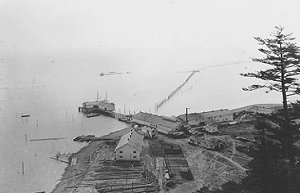
Alaska Packers Cannery at Lily
Point c.1893 |
 |
|
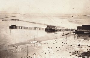
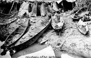
Native American canoes at Lily
Point fishing camp |
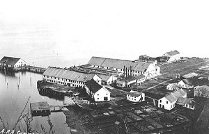 |
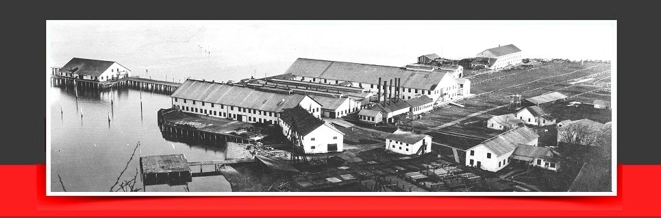
Alaska Packers Cannery at Lily
Point fully
built out in 1897 |
|